
Iceland is a volcanic island in the North Atlantic, just south of the Arctic Circle. Here, the Mid-Atlantic Ridge rises above the sea. Glaciers cover about a tenth of the country. Meanwhile, the Ring Road, Route 1, circles the island for roughly 1,320 kilometres. Fewer than 400,000 people live here, most of them in and around Reykjavík, the capital.

Iceland in February
Our Iceland archive comes from one week in February 2020. I had wanted to photograph this island since I was a teenager. Then Skylum invited me to its first Luminar Camp, and the plan became a booked flight.
The EXIF data gives the route. On 8 February, we stood at Skógafoss at midday. Two days later, we were in the southeast, at a frozen glacier lagoon after lunch and at Vestrahorn after sunset. On 11 February, we went into an ice cave under Vatnajökull, then drove west to Seljalandsfoss for the last light. Finally, on 12 February, we finished in Reykjavík.
A few weeks later, the first lockdowns closed Europe. So that week became the last trip of its kind for a long time. Consequently, every frame in this guide comes from it.
Seljalandsfoss
Seljalandsfoss drops about 60 metres from an old sea cliff, right beside Route 1 on the south coast. In February, the day is short, and this sunset was the last one of the trip outside Reykjavík.
I set up low and wide beside the plunge pool. The fall stands on the left, and the sun sits on the horizon. Meanwhile, two small figures walked the snowy path at the centre of the frame. Above all, they give the waterfall its size. Without them, this winter sunset at Seljalandsfoss would read as a much smaller scene.

A path leads behind the curtain of water. During summer, the walk is easy. In winter, however, ice covers the rocks and spray freezes on every step. Therefore, take crampons, or simply watch from the front.
Skógafoss
About 30 kilometres east of Seljalandsfoss, Skógafoss falls 60 metres over a curtain 25 metres wide. The cliff behind it marks the old coastline. Today, the sea lies about five kilometres away.
We reached it on the first day, at midday. Unusually for February, the slopes showed brown grass instead of snow. On a sunny day, the spray throws a rainbow across the basin. That day, instead, the clouds kept moving and the mist hung low.
Look closely at Skógafoss from the riverbed and you find a figure in a red jacket at the base. In fact, that dot is the scale. Marvel fans may recognise the view as well, since Thor: The Dark World filmed here.

Vík í Mýrdal
Vík í Mýrdal is the southernmost village in Iceland, about 180 kilometres from Reykjavík. It has no harbour, which is unusual for an Icelandic coastal village. Even so, it grew from a meeting place where farmers traded goods into the main stop on the south coast.
However, the best view is from the hill above the village. From there, Vík Church above the snowy rooftops fills the foreground. The street lights were already on, and the blue hour lay on the snow. Offshore, the Reynisdrangar sea stacks stand in the bay.
Since 1934, the church has stood on that hill. According to locals, it is the safest place in the village if Katla erupts. The volcano lies under the Mýrdalsjökull ice cap, and its floods would cover the plain. In summer, puffins also nest on the cliffs nearby.

Vatnajökull
Vatnajökull is the largest ice cap in Iceland and covers about eight percent of the country. Moreover, by volume it is the largest in Europe. Active volcanoes lie beneath the ice, and its outlet glaciers feed the lagoons along the south coast.
On 10 February, we stopped at what looked like an ordinary frozen lake. The plan was simple: a wide lens, close to the ice, with air bubbles in the foreground. However, across the lagoon stood a wall of glacier in shades of cyan I had never seen in nature.
So I put the wide lens away. Instead, I reached for the telephoto on the Nikon D800, at 200mm and 1/500s. Then three people walked out along the edge of the lagoon. When they lined up below the ice, I pressed the shutter. That frame became the glacier lagoon with three walkers, and the three dots carry the story of scale.

Ice Caves and Glacier Tours
The next morning, we went off-road into the interior and then hiked for half an hour onto the glacier. Ice caves form under Vatnajökull every winter and melt away again. As a result, a cave that exists this week may be gone next week. Therefore, certified guides scout and secure the routes every morning. Nobody should ever enter one alone.
Once inside, we stood under a ceiling that glowed blue. A figure in an orange suit stood still for a full second while I made the ice cave under Vatnajökull. Since then, that frame has become our most visited Iceland page.

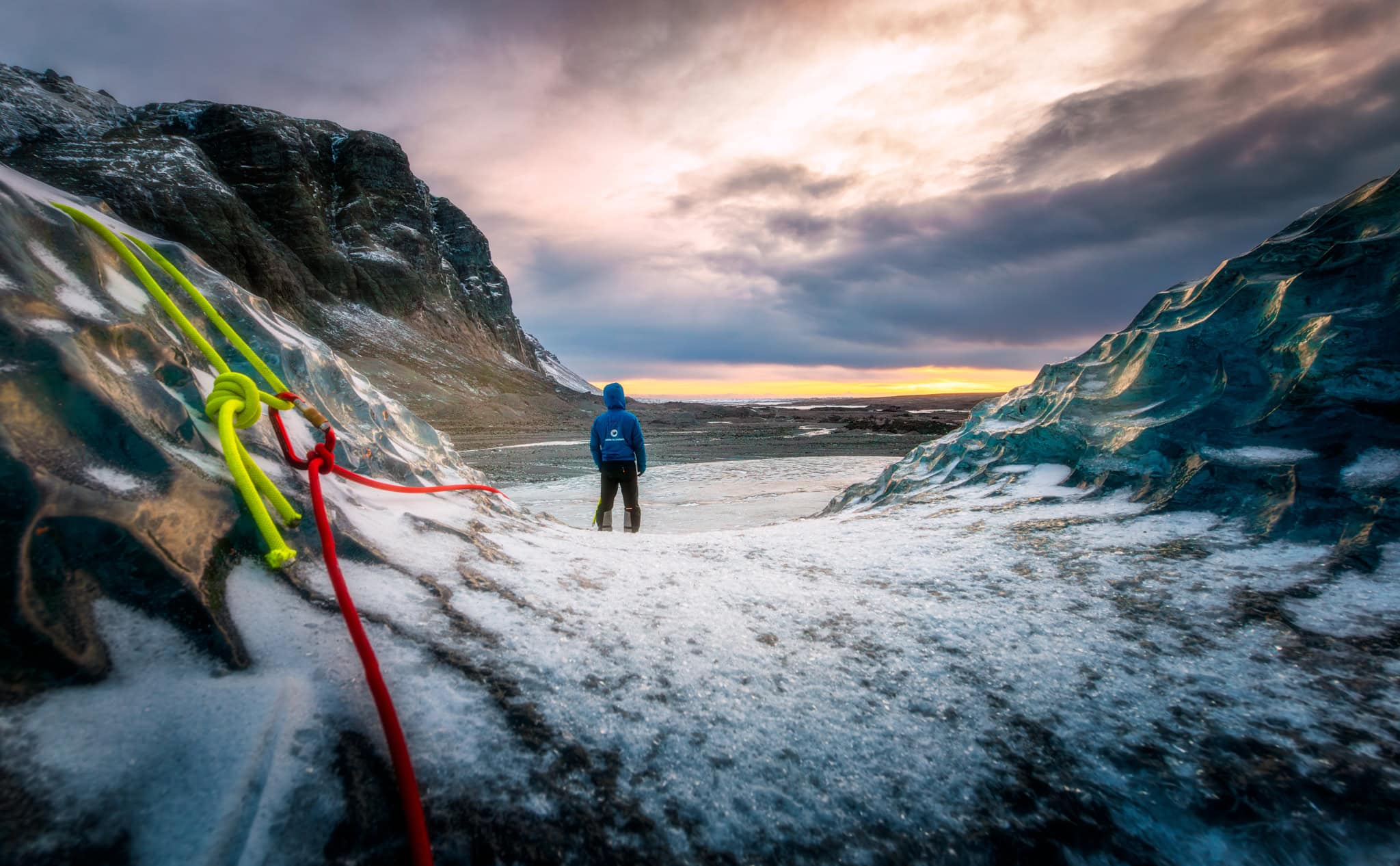
Thirty-two minutes later, we climbed back out over a glassy hump of ice. Earlier, the guides had fixed neon ropes for the climb. At the crest, the lead guide from Guide to Iceland stopped and simply looked. Then an orange band opened under the clouds. I shot the guide at the crest of the glacier at 15mm and ISO 64. Also, I added +0.3 EV to hold the ice. The ropes lead the eye in, and then you find him.
Both caves and lagoons belong to Vatnajökull National Park, which UNESCO lists as Dynamic Nature of Fire and Ice.
Vestrahorn
Vestrahorn rises from the Stokksnes peninsula, a short drive east of the town of Höfn. From Reykjavík, the drive takes about six hours. The mountain is gabbro and granophyre, so the rock looks dark brown in summer. The access road crosses private land, and the farm charges a small fee at the Viking Café.
We arrived on 10 February, after the lagoon. By then, the sun had already set. Still, snow covered the peaks, and the black dunes below held tufts of golden grass.
I went low into the dunes at 17mm, so the grass leads up to the ridge. The result is Vestrahorn above the black dunes, in blue winter light. In summer, by contrast, the same mountain is dark and the grass is green.
Hallgrímskirkja
Hallgrímskirkja is the tallest church in Iceland, at about 74.5 metres. Guðjón Samúelsson designed it in 1937, and the stepped concrete wings recall the basalt columns of the Icelandic coast. Building began in 1945. However, the church was consecrated only in 1986.
Guðjón drew on Expressionism. In Copenhagen, the same movement shaped the pale brick vaults of Grundtvig’s Church, which I photographed as well. Besides that church, our Copenhagen guide covers the rest of the city.
On 12 February, our group set up at the front of the church, as nearly everyone does. I went round the side instead. From there, the low February sun broke past the tower, and the statue of Leif Erikson stayed in the frame. The United States gave that statue to Iceland in 1930. In the end, the side view became Hallgrímskirkja with the sun at its corner.

Sun Voyager
On the shore road Sæbraut, a steel boat points out over the bay. Jón Gunnar Árnason designed Sólfar, the Sun Voyager, for the 200th anniversary of Reykjavík in 1986. It was unveiled in 1990, the year after his death.
Although it looks like one, it is not a Viking ship. Rather, Jón Gunnar called it a dreamboat and an ode to the sun. He drew on a story of travellers who sailed towards the setting sun. They were searching for their homeland, and so they reached Iceland.
Across the water, Mount Esja carries snow down to the shore. Above it, the winter sky turned pink and violet. I made the Sun Voyager under a pink winter sky from the side. That way, the bow points into the open space.

Photographing Iceland
Iceland is easy to photograph and hard to photograph well. Every famous view has been shot thousands of times. Therefore, a frame has to earn its place with something more.
Here, that something was scale. First, Skógafoss has a red dot at its base. Second, Seljalandsfoss has two walkers, and the lagoon has three people under the ice wall. Above all, there is the guide on the crest. In each frame, a person shows the size of the place.
The archive also keeps working. We published the first Iceland frames in 2021, and the lagoon and the guide in November 2025. In the last 90 days, the ice cave page alone brought 61 clicks from Google across all languages. Meanwhile, the Vík frame collected over 12,000 image impressions. A week of work from 2020 still earns traffic six years later.
Getting Around Iceland
Most visitors land at Keflavík International Airport, about 50 kilometres southwest of Reykjavík. From there, a rental car is the simplest way to see the south coast. Seljalandsfoss, Skógafoss and Vík line up along Route 1 within a day’s drive of the capital.
By contrast, Höfn, Vatnajökull and Vestrahorn are much further east. Therefore, plan at least one night in the southeast. In winter, check road.is for road conditions every morning, since storms close sections of Route 1 at short notice.
Iceland is not in the European Union, but it is part of the Schengen Area. It uses the Icelandic króna, and cards work almost everywhere, even at remote petrol stations.
Frequently Asked Questions
What is the best time to visit Iceland?
It depends on what you want, since winter and summer look like two different countries. From November to March, you get snow, ice caves and long twilight, but only a few hours of daylight. Summer brings the midnight sun, green slopes, open highland roads and puffins on the cliffs. Our February trip had under eight hours of daylight, and the low sun lit every frame.
How many days do you need in Iceland?
A long weekend covers Reykjavík and the south coast waterfalls as far as Vík. A week reaches the southeast, with Vatnajökull, the glacier lagoons and Vestrahorn. Finally, ten days to two weeks allow the full Ring Road. In winter, add a spare day, because storms can close roads for a day or more.
Can you visit an ice cave in Iceland on your own?
No. Ice caves change every season, and some collapse within days. Certified guides check and secure the routes every morning, and they provide helmets and crampons. Tours into the caves under Vatnajökull usually run from about November to March. Book ahead, since groups are small and the season is short.
Can you walk behind Seljalandsfoss in winter?
Sometimes. A path leads behind the waterfall. However, in winter the spray freezes on the rocks, and the path is often icy or closed. Wear crampons or microspikes, and turn back if the ground looks unsafe. The view from the front, especially at sunset, is equally strong.
How far is Vestrahorn from Reykjavík?
Vestrahorn lies on the Stokksnes peninsula near Höfn, about 460 kilometres east of Reykjavík along Route 1. The drive takes around six hours without stops, and longer in winter. Most photographers combine it with Vatnajökull and the glacier lagoons, staying overnight in or near Höfn.
Can you see the northern lights in Iceland?
Yes, from roughly September to April, when the nights are dark enough. You need clear skies and solar activity, so no date is guaranteed. Also, leave the lights of Reykjavík behind for the best chance. The Icelandic Met Office publishes a daily aurora and cloud cover forecast.
What currency does Iceland use?
Iceland uses the Icelandic króna (ISK). Cards, including contactless payment, are accepted almost everywhere, from Reykjavík cafés to petrol stations on the Ring Road. Therefore, many travellers never need cash. Iceland is part of the Schengen Area, but not of the European Union, so the euro is not used.


